Hampta Pass Trek
Hamta Pass is a hall withinside the Himalayas, among the Chandra Valley in Lahaul and the Kullu valley of Himachal Pradesh, India. Hamta Pass that is placed at 14000ft top from sea level.Beauty of Himalaya in Himachal Pradesh which you cannot witness from a avenue trip! Had fresh fun time with nature with out internet, telecellsmartphone community and electricity. Hamta Pass connects Kully Valley and Spiti Valley. It was once travelling location in the course of historical time. The byskip is known as after Hamta Village, beneath Sethan village.. It additionally gives trekkers a completely unique possibility to revel in the existence withinside the remotest of villages in useless winter!Hamta Pass is a hall withinside the Himalayas, among the Chandra Valley in Lahaul and the Kullu valley of Himachal Pradesh, India.The byskip is known as after Hamta Village, beneath Sethan village. Lower Himalayan shepherds use the byskip in summer time season for its excessive altitude grasslands withinside the summer time season, whilst the desolate tract of Lahaul is barren.The Hamta byskip Trek is one of the first-class course for novices and nature lover. The lush inexperienced forests and delightful panorama will land you from Manali to Spiti valley.
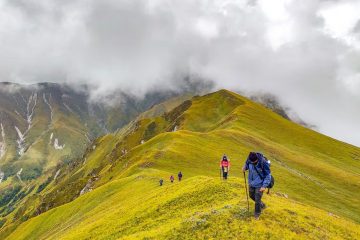
Hikers tour from the Kullu valley via Hamta Pass, and into the area of Lahaul. The course consists of glaciers and fast-flowing rivers, making it tough however viable for a few novices. Some hikers keep to Chandrataal lake.
The nearest hub is Manali, in Himachal Pradesh. Most itineraries consist of delivery from Manali to Jobri, from wherein the trek begins. Depending at the trek itinerary, it usually takes three to four days to finish the trek. Hikers may also forestall at Chika, Balu ka Gera, or Chatru.
The first-class time to trek to Hampta Pass is from mid-June to mid-October. There are probabilities to witness a few snow at the excessive passes withinside the early days of the season after which it melts down absolutely with the aid of using August. Rain is predicted in the course of the monsoons in Kullu-Manali valley however in Spiti, the solar could be brilliant as usual.
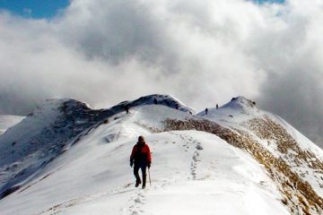
Trek Highlights
The best season to visit the Hamta Pass trek is from April to October, after which there is a risk of slipping on the trek due to the rainy season.
During April to October, the weather here is mostly clear, due to which you can enjoy the nature here.
To go on this Trek, you have to go along the Chandra River, in the middle of which you get a chance to see small meadows, waterfalls, and snow-capped mountains of the beautiful Dhauladhar.
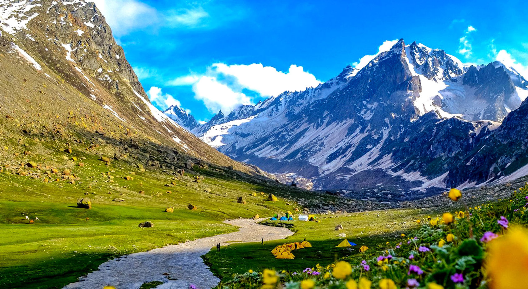
You can see the beautiful hills of Dev Tibba, Indrasen Peak, Indarkila Inderkila, and the surrounding beauty of snow-capped mountains. The height of Hamta Pass is about 14,000 feet.
This Hamta Pass Trek starts from Manali and ends at Chataru near Chandratal. You have to go along the Hamta Pass where in the middle you can see the beautiful weather and green natural shade changing every moment, which gives tourists a look. Takes you to a different world.
For those who like adventure sports, this trek is no less than a surprise. Here the icy winds blow every moment, seeing the mist of white clouds between the standing pine trees around and it seems as if you are going on the way towards heaven.
Seeing all this, you will not even believe that you are going to travel on any Trek. This experience will never be forgotten in your life.
On this Hamta Pass Trek, like other Trek, you do not get the necessary things like food, drink, T-House, and mobile connection anywhere in the middle.
Mobile networks can also be available to you only till Prini. After that, you are complete with nature and in nature’s lap. But the way to go here is good, due to which you can easily complete the Hmata Pass Trek.
This entire Hamta Pass Trek is about 26 km, on which it takes about 5 days to reach and leave.
Day 1: Manali To Chika
• Altitude: Jobra – 3000 m/9,800 ft to Chika 3100 m/ 10,100 ft.
• Drive: 2 hr to Jobra from Manali
• Trek Distance: 2 km Duration: 45 minutes from Jobra
• Enough water through the trail
• Easy to moderate trail
• Stay in tent
• Pick Time: 12 pm
• Reach Chika campsite by 5 pm
Day 2: Chika to Balu Ka Ghera
• Altitude: 3,600 m/ 11,900 ft.
• Trek Distance: 8.5 km | Duration: 5 to 6 hrs.
• Altitude Gain: 500 m/ 1,800 ft.
• Moderate trail, gradual ascent.
• Packed lunch will be provided
• Enough water on the way.
• River crossing, boulder walk, and colorful tiny flowers on the way.
Day 3: Balu Ka Ghera To Shea Goru Panoramic Mountain Views
• Trek Distance: 7 km | Duration: 10 hr
• Altitude Gain: 300 m/1,000 ft
• No water point on the way
(depends on the condition of snow) • First 1 hr gradual ascent then steep ascent till the pass
• Packed lunch at the pass, enjoy the view of Indrasen Peak • Around 2 hrs of steep descent and 1 hr of flat walk from the pass to the campsite
• The coldest part of the trek
• Stay in tent
Day 4 : Shea Goru To Chatru
• Trek Distance: 7 km | Duration: 5hr
• Drive Distance: 49 km 3 hr to Chandratal and back to the campsite, either on day 4 or day 5 (depending on road and weather conditions)
• Altitude Loss: 550 m/1,900 ft
• Gradual descent on the moraine
• Start early in the morning
• 2 to 3 water sources on the way
• Hot lunch at campsite
Day 5: Chatru To Manali
• Breakfast at campsite
• Lunch on the way
• Make your further plan from Manali
Day 1-Manali to Chika via Jobra
Your adventure with A1 Himalayas begin from manali. The hiking excursion begins offevolved from Manali to Jobra . Manali is already at an elevation of 6, seven-hundred toes above sea level. So, it is a great vicinity to acclimatize your frame earlier than starting the trek. It takes hour and 40 hairpin bends to reach at Jobra. Jobra is at an altitude of 9, 800 toes. On the primary day you’ll attain a top of 10, 100ft and cowl up to 3 hours of trek.
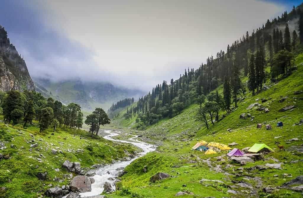
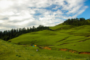
The trek taking walks initiates from Allain Guhugal Hydel Project junction. After crossing the principle road, take the small direction that results in the woodland of pine bushes. You may also locate different sort of bushes like maple, deodar, toss and oak. The sight is refreshing. The slope that is meant to be climbed is an smooth one and now no longer very steep. Twenty mins into the trek, you’ll attain a bend that overlooks a lush inexperienced meadow strewed with small rocks. Enjoy the encircling for a few minutes and head in the direction of the meadow. The Rani nallah comes into view which flows without delay in among the meadow. You may also see few sheep and cows grazing withinside the field. The sight seems precisely as though taken out from fairy tale. You can byskip via the meadow or climb up the hill at the left hand side. Either manner you’ll attain Chika that is on the cease of the widespread meadow. But, mountaineering the hill and descending right all the way down to Chika is a higher and less difficult route. Chika camp webweb page is a huge, spacious patch of inexperienced. The Rani River flowing withinside the center makes this vicinity ideal for putting in the tents.
Day 2- Chika to Balu ka Ghera
After crossing the waterfall, the subsequent direction is closer to the river in your left. You can visit the opposite facet handiest through crossing the rivulet through wetting your feet. The water is notable bloodless and could clearly prick your feet. You also can leap from one rock to some other withinside the move and get to the alternative facet. You ought to have completed 1/2 of of the day`s trek whilst you input Jwara. Jwara is a lovely scenic sheltered valley; big snow clad rocks at one facet and the valley drops right all the way down to the river on the opposite facet. You will experience like immersing your self withinside the splendor of God`s nature. You will locate snows melting into the river and farm animals grazing the land. In the front of the photograph is snow clad mountains and at the back of them lies the Hampta Pass. From here, the path could be through the river facet with a purpose to lead you to some other square valley. The route is included with multi coloured flowers. The closing of the tree traces vanishes out of the sight and is left at the back of. It will take some other 1/2 of an hour or to be able to attain the give up of the valley, that’s the completing a part of Jwara. After Jwara, the route is a slope included with snows and rocks. The give up of the route is Balu ka Ghera, the call has not anything to do with the area. The area is included with snow and veggies while the call suggest mound of sand. But it’s far stated that this area turned into fashioned with the sands and dirt deposited through the river. Balu ka Ghera campsite is a flat floor amidst the mountains that you may move the following day to attain the pass. Balu ka Ghera is at an elevation of 11, 900 ft…
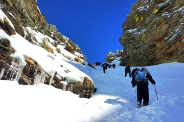
Day 3- Balu Ka Ghera to Siagoru crossing Hampta Pass
You will attain any other plateau after which to a ridge. It will take any other 1/2 of an hour to attain the ridge`s end. Then from the primary ridge trek in addition as much as get on the second one ridge. Hampta Pass is only some meters and a bend far far from the second one ridge. The climb to Hampta Pass is a vertical one and is a difficult mount. It will take approximately 15 mins to attain the byskip. Yes, by the point you attain there, you’ll be extraordinarily worn-out however the web website online which enfolds in the front of you is stunning. Enjoy for someday with inside the by skip, get pleasure from the splendor around, have your lunch after which get geared up for the following descent to Siagoru.
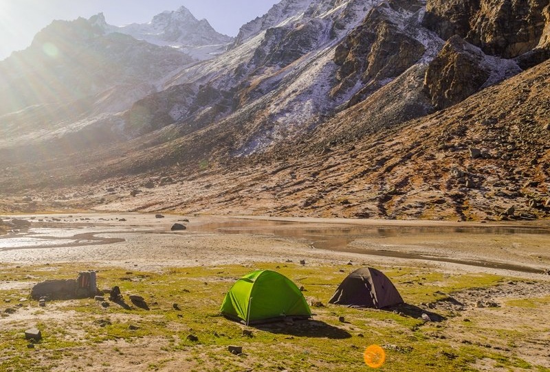
The descent is trickier than the adventure to the byskip. The decline is so steep which you could now no longer be capable of find the bottom of the mountain, now no longer even through craning your neck. The nice viable manner to get down is both through sliding down the slope or with the usage of ropes for support. The direction is a touch meandering too. You will even spot Spiti from this point. In an hour and a 1/2 of you may attain the bottom of the valley as a way to lead you to Siagoru. The valley is secured through snow clad mountains, and the facet that’s open is Siagoru`s manner. The trek to Siagoru is simple on flat land. The Siagoru camp web website online is likewise through the river facet. Set your camps at the grounds and retire for the night time with a sense of contentment on the heart.
Day 4- Siagoru to Chatru and drive to chandratal| bask in the serenity of the lake
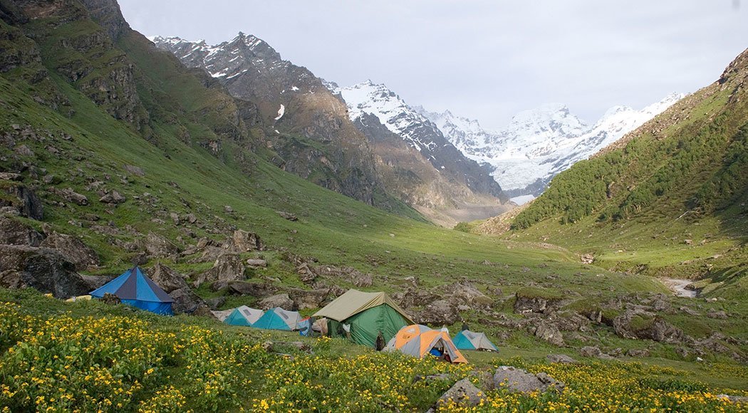
The intricate component comes subsequent.You will need to be cautious because the path may someday lead you to edges of mountains and ridges. The direction has slippery elements too. So, certain footed and cautious navigation is needed to move further. Nevertheless, the trek isn’t always that hard because it sounds. You will for certain revel in the sliding and coronary heart pumping mounting. Getting down the mountains will devour some other hours of your time. You will note the Chandra River flowing beneath and a avenue that is going with the aid of using its facet. More than Glaciers comes subsequent which might be to be crossed. The different facet of the Glacier is Chatru, the following tenting zone. Choose a region which has the river walking around. Chatru is a astonishing tenting site; it’s miles a consensus of the 3 passes, Hampta, Rohtang and Spiti. The region is pretty much some other hour
Day 5- chatru to manali
An in a single day adventure after 06:00pm to Delhi will with a bit of luck workout best
We desire you had a awesome time and journeying revel in with A1 Himalayas and we desire you a secure and snug adventure ahead.
By Air :-
You can even take a flight to Bhuntar Airport but I would not recommend it because of the high prices of the flight and very high chances of cancellations. In case you do reach Bhuntar by flight, Manali is just a couple of hours away and you can easily get a bus or a private taxi till there. If you do plan to come via Bhuntar, make sure to reach at least a day before the trek starts.
By Train :-
Delhi to pathankot railway station is from where you can get direct buses to manali that is 300 km from there and would take an overnight journey.
By Bus:-
There is regular bus service from Delhi to manali, from Delhi to ISBT Kashmere Gate. We would suggest you to take only government buses from ISBT Kashmere Gate. Private buses ply from outside ISBT and they are not trust worthiness. Usually buses drop you at Dehradun ISBT. From there you have to come to Dehradun Railway Station
Includes
- Meals during the trek
- Dinner on arrival day in manali
- Forest Permits/Camping Charges (only if availing transportation through A1 Himalayas). Included only upto amount charged for Indian Nationals
- Tents, Sleeping bags, mats
- Safety Equipment includes static rescue rope, seat harness, carabiners, pulleys
- Trek guide, cook, helpers, porters & mules for carrying common luggage
- Services of a Certified Trek Leader
Excludes
- Meals during road journeys
- Transportation from manali to manali.
- Carriage of Personal Bags during the trek
- Any kind of Insurance
- Any expense of personal nature
- Any expense not specified in the inclusion list.
1) Trekking Shoe/Snow Shoe
2) Rucksack/Back Pack
3) Rucksack cover (Waterproof)
4) Daypack/Knapsack
5) Undergarments/Innerwear
6)Woolen socks
7) Woolen gloves
8) Waterproof gloves
9) T-shirt
10) Trek pants
11) Camp sandal
12) Balaclava/Woolen skull
cap/Monkey Cap
13) Sun cap/Wide-brimmed
Hat/Bandana
14) Walking Sticks/Trekking
Poles/Ski Poles
15) Heavy Jacket
16) Windproof Jacket/Wind
Cheater
17)Raingear/Poncho/Waterproof clothing
18) Water bottle/Hydration pack
19) Sunscreen lotion
20) Sunglasses
21) ChapStick/Cold &
Moisturizing cream
22) Toothbrush and toothpaste
23) Towel
24) Hand sanitizer
25) Tissue roll ( Toilet)
26) Anti Fungal Powder
27) Torch/Head Lamp with extra batteries
28) Knee cap
29) Camera with extra cells
30) Dry food items
31) Personal first-aid kit
32) Medicines (This is a simple
guide line and a doctor’s
consultation is recommended.)
Altitude is a risk. Before you begin the trek, you should be aware of the effects of high altitude on your body. Acute Mountain Sickness (AMS) symptoms include a moderate headache, nausea, and overall discomfort.
Reponse: If you have any of these symptoms, notify the trek leader immediately and follow his advice. To deal with the scenario, each campsite contains a stretcher, a fully prepared first aid kit, and oxygen cylinders.
Weather Risk : No one can guarantee snow, rain, or sunlight, even if we keep a constant eye on the weather. Please keep in mind that your safety is our primary priority, and if the weather isn’t cooperating, we won’t leave the campsite.
Response: The choice to go or wait for better weather will be made solely by the Trek Leaders and Guides.
Risk: Injury is a possibility. While trekking across difficult terrains, minor injuries such as calf sprains, bruising, and other minor ailments are prevalent. Serious injuries, such as fractures or significant cuts, are quite uncommon.
Response: All of our Trek Leaders are trained in wilderness first aid. They’ve been taught to deal with emergencies and have a well-stocked first-aid equipment to deal with minor injuries. In the event of major injuries, the patient is carried to the nearest road-head on a stretcher and taken to the nearest medical facility.
DO’S AND DON’TS ON A TREK
1. Alcohols or any other intoxicating products ‘’STRICTLY PROHIBHITED’’
during the trek.
2. Always pay heed to the trek guides or instructors.
3. Try not to leave the group under any circumstances.
4. Avoid trekking during the nights as it is extremely dangerous.
5. Avoid using earphones as that might hinder your hearing.
6. Do not participate or encourage littering of the places in any form.
7. While visiting the local villages and tourist sites, obey the local guidelines
and instructions.
8. Do not harm or interrupt the local sentiments of the places.
IMPORTANT:
Your safety is of paramount concern while traveling with A1 Himalayas.
Please note that your leader has the authority to amend or cancel any part of
the itinerary if it is deemed necessary due to safety concerns. Since adventure
entails traveling in remote mountainous regions, we cannot guarantee that we
will not deviate from it. Weather conditions, health condition of a group
member, unexpected natural disasters, etc., can all contribute to changes in
the itinerary. The leader will try to ensure that the trip runs according to plan,
but please be prepared to be flexible if required.