Har Ki Dun Valley Trek
Region :– Uttarakhand Duration :-7 days Grade :- Easy To Moderate Max Altitude :– 12,000 ft Trek Distance :– 44 Km Base Camp :– Sankri Pickup/Drop Point :- Dehradun Railway Station.
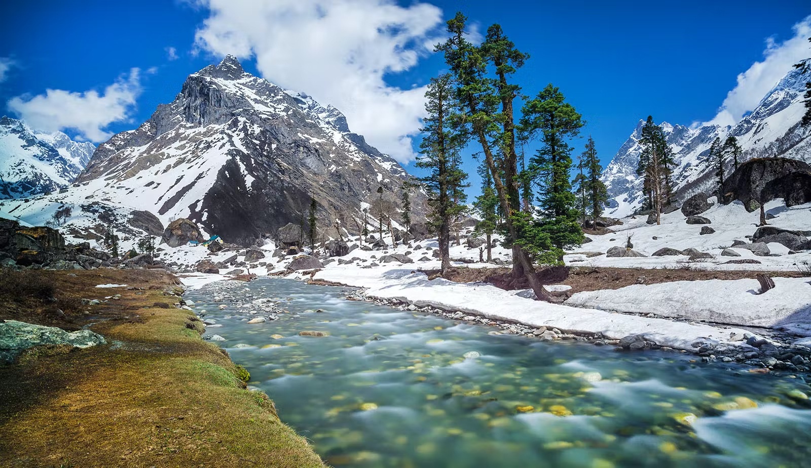
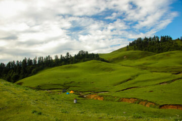
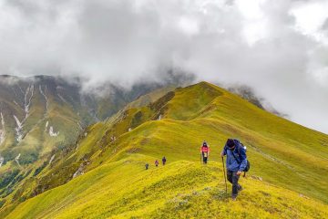
Har Ki Doon, or Har Ki Dun, is a cradle-formed plateau valley inside the Garhwal Himalayas of Uttarakhand, India. The location is surrounded by inexperienced Bugyals (High Altitude Meadows). It is surrounded by snow-blanketed peaks and alpine vegetation.
Har Ki Dun is the most popular and top-rated hiking destination because it allows you to experience the splendour of Uttarakhand.
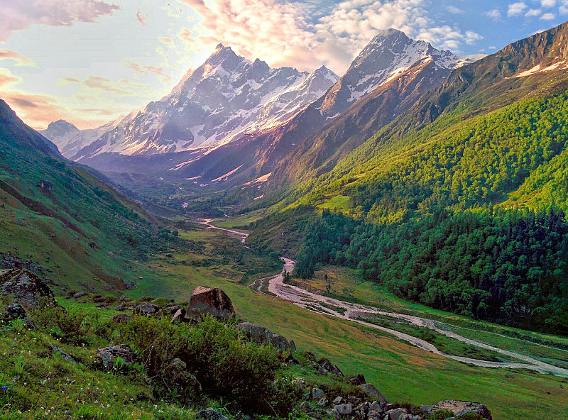
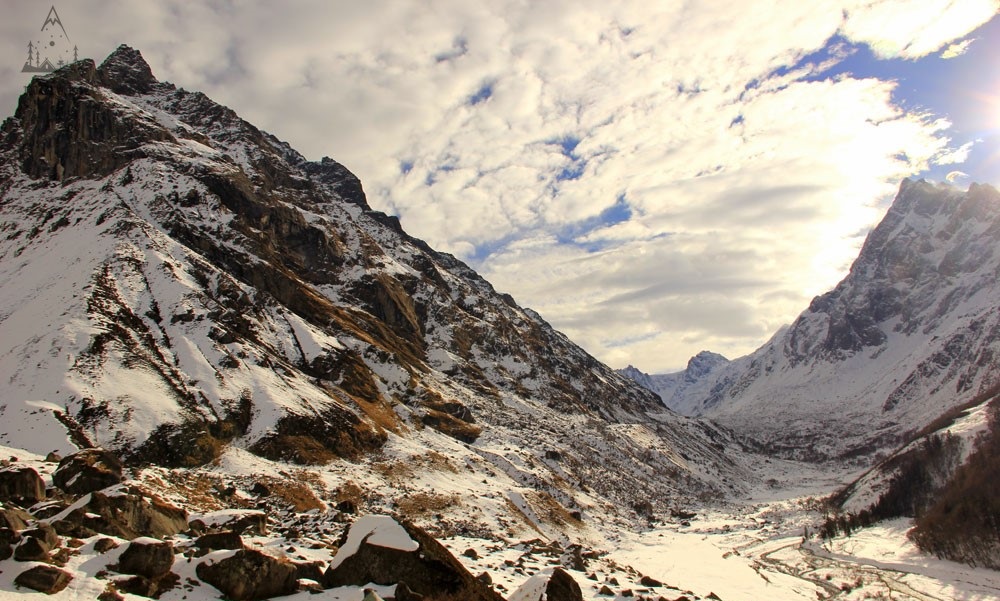
From December to March, the entire valley stays blanketed in snow, providing you with lovely views. Trekking in this region entails visiting jaw-dropping viewpoints of famous Himalayan peaks such as Bandarpoonch, Swargarohini, and Kala Nag.During the trek, you’ll also find picturesque Garhwali villages.
This trek is clearly a stairway to paradise, a good way to absolutely fall in love with its captivating beauty.
Trek Highlights
Whole of the har ki dun trek is ethereal with views of rivers, mountains, meadows and also with beautiful ancient villages with rich cultural heritage making your trek a memorable event. The dainty wooden houses in the height are prepossessing sight and seems to be hanging in the air from distance. People are warm and welcoming, giving you a peek in their culture and lifestyle. The journey of the trek have several highlights including:
Mountain peaks of Bandarpoonch, Kalanag (Black Peak) and Swargarohini. It is believed that Pandavas begin their journey to heaven from Swargarohini peak.
Jaundhar Glacier with lofty peaks and rock formations giving this place the charm and dazzling of its own.
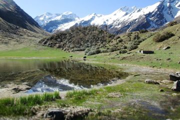
MARINDA TAAL is the high altitude lake with Swargarohini peak overlooking in the background. It can explored after reaching the Har ki dun Valley.
Har ki dun trek is considered to be the ideal pick for beginners as it is not at much altitude but still at a sufficient height to imbue with the exhilirating experience of trekking and scenic view of BANDARPOONCH, KALANAG and SWARGAROHINI peaks. The Har ki dun trek is a 7 day long trek staring from the village of Sankri in Uttarkashi which is a 9 hour long drive from the city of Dehradun. Thereafter the trek advances to Taluka, Seema/osla and eventually to the picturesque view of Har ki dun
Day 1 – Dehradun to Sankri
220 km drive by NH 507 – approx 10 hours.
Altitude : 1,950m/6,400ft.
Last ATM- Purola/Mori.
Small shops available for trekking gears and miscellany.
JIO/BSNL network erratic.
Guest House Stay.
Breakfast and lunch excluded, dinner included.
Trekkers will be picked from Dehradun at 6:30am in a Tata Sumo or a similar vehicle.
Expected arrival time at Sankri – 6:00 pm.
Day 2 – Sankri to Pauni Garaat via Taluka
Sankri to Taluka (Drive 12 km) (1 hour).
Altitude of Taluka – 2,100m/7,000ft.
Taluka to Pauni Garaat.
Altitude – 2,500m/8,200ft.
Trek Distance – 10km.
Trek Time – 6 hours approx.
Trek Level – Easy level walk and gradual ascent in most parts.
Packed lunch.
Spring water points.
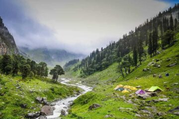
Riverside camping in Govind National Park forests.
Day 3 – Pauni Garaat to Kalkattiyadhaar
Altitude – 2,950m/9,800ft.
Trek Distance – 8 km.
Trek Time – 6 hour.
Packed lunch.
Spring water points.
Trek Level – Steeper ascent than last day, but well distributed in level walks and inclines.
Camp stay in forest overlooking mountains near a food stall.
Day 4 – Kalkattiyadhar to Har Ki Doon & back to Kalkattiyadhar
Altitude – 3,400m/11,800ft.
Trek Distance – 10 km.
Trek Time – 9 hour.
Packed lunch.
Spring water points.
Trek Level : Relaxed forest walk combined with boulder walk. Mixed gradient with gradual incline.
Camp stay in forest overlooking mountains near a food stall.
Snow Peaks in View : Swargarohini, Hata Peak, Black Peak etc.
Day 5 – Kalkattiyadhar to Pauni Garaat via Osla
Altitude – 2,500m/8,200ft.
Trek Distance – 8 km.
Total Trek Time – 5 hour.
Packed lunch.
Spring water points.
Riverside camping in Govind National Park forests.
Day 6 – Pauni Garaat to Sankri via Taluka
Altitude – 1,950m/6,400ft.
Trek Time – 5 hour.
Trek Distance – 10 km.
Packed Lunch.
Spring water points.
Drive from Taluka to Sankri – 12 km.
Driving Time – 1 hour.
Guest house stay.
Day 7 – Sankri to Dehradun
Distance – 220 km drive, approx 10 hours.
Driving Time – 10 hour.
Driving Time – 7 am-6 pm.
Breakfast and lunch excluded.
You will be dropped at Dehradun station in a Tata Sumo or a similar vehicle.
Day 1- Drive from Dehradun to Sankri (1950 m)
Trekkers could be picked up from Dehradun railway station or ISBT bus stand at 6:30 AM. Before completing Sankri, we can visit Mussoorie, Naugaon, and Netwar. We will travel down the scenic route and you may see pine tree forests on both sides.
In the nighttime through 6PM, we can be accomplished in Sankri, and after freshening up, you can discover the marketplace in Sankri.
This trek is absolutely a stairway to paradise to be able to genuinely make you fall in love with its spellbinding beauty.
Day 2- Sankri (1950 m) to Taluka (2108 m) by road Trek from Taluka (2108 m) to Pauni Garaat (2500 m)
There is a motor-able road stretching over 12 km that connects Sankri to Taluka. We start at 8 AM and drive through a forest road flanked by Deodar and Bamboo trees. Streams of clear water swerving down the hills accompany you throughout this stretch. The drive is a delight for all nature lovers as you will be able to spot rare Himalayan birds like the Himalayan Raven, Red-Billed Blue Magpie, and Himalayan Bulbul.
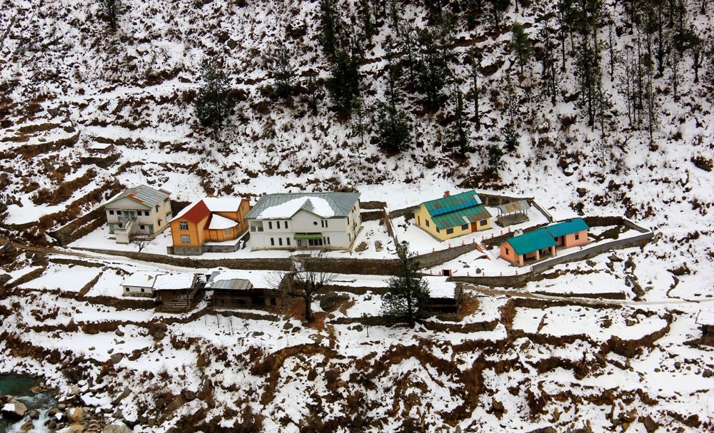
It takes an hour to reach Taluka. Taluka is a small picturesque hamlet with a cluster of concrete houses and a couple of government guest houses. The gushing Supin River flowing across the village dominates the landscape.
After a short break of refreshments, we begin the 9 km trek towards Pauni Garaat. The trek commences on an uneven stony trail that runs out of the village. A few minutes into the trek, the trail expands into an open land and you will find yourself walking along the banks of the Supin River.
Eventually, the trail translates into a level walk through dense lush conifers where you spot the first cemented bridge running over a small gentle stream. After about 20 minutes, you will come across another wooden bridge over a stream. You can fill your water bottles here.
The hike is quite pleasant throughout as you will be walking under the shade of Walnut, Pine and Cedar trees accompanied by the sound of the flowing river. You might even find walnuts on the ground in autumn. The gradient of the trail is easy mostly with gradual ascents. You will often see mule-traffic along the way accompanied by locals carrying heavy loads on their backs in preparation for the long winters.
A couple of hours into the trek, you will see the small village of Gangar on the other side of the river. Small wooden shops serving tea and snacks dot the landscape. We will be taking a quick halt here to have our packed lunches.
The trail out of the Gangar village runs along the right hand side of the river. Fields of Potato and Maize can be spotted along the way. The campsite for the day, Pauni Garaat, is situated in a vast clearing enroute. The actual village of Pauni Garaat, however, is located on the other side of the river.
After setting up camps and freshening up, take some time to explore the area around the campsite. Have a hot dinner and tuck in early to get ample rest for the next day.
Pauni Garaat (2500 m) to Kalkattiyadhaar (3024 m)
The day begins with a short session of yoga and stretching to pump up for the trek ahead. Post breakfast, we commence the 8 km long trek to Kalkattiyadhaar. The trail runs through a thicket of towering forests culminating in the village of Seema. It is marked by a sparse cluster of concrete structures and a forest department guest house set on the banks of the Supin River. The Osla village is located on the other side of the river, at a slightly higher elevation of about a hundred metres.
Next to the village of Seema lies the infamous Seema Bridge, a large hanging bridge running across the Supin River with a backdrop of colossal mountain ranges. The jewel-blue Supin River can be seen sparkling as it winds its merry way through the boulders.
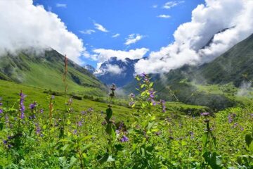
Once you cross the bridge, get ready for a steep climb all the way up to the point where we meet the trail coming out of Osla. Expansive farms, mostly growing Amaranth, dominate the landscape here. You will find villagers working in the farms. During monsoon, the amaranth takes on a deep reddish hue adding a striking contrast to the scenery. After half an hour, the trail opens up to grand snow-capped views of the Banderpoonch and Swargarohini ranges.
The trail gradually climbs higher beyond this point passing by a variety of flowers like fleece and sunflowers. As we make our way past a couple of fields, the river Supin retreats from view far below. This stretch is blessed with some magnificent viewpoints of the Dhauladhar ranges.
The trail eventually culminates at a ridge locally named as Kalkattiyadhar. Our campsite, lays a short descent away from this ridge. Expect to reach the campsite by 1 PM in the afternoon.
The Kalkattiyadhar campsite is a beautiful open meadow set in an exquisite location. You will be able to spot some renowned peaks like the Buyal Devsu and Mt. Black Peak from here. You will also be able to see the Ruinsara Range running on the left and the Kedarkantha Summit on the right. Take a breather basking in the expansive views of the valley and the warm sun. This day being a short one gives ample time to the trekkers to acclimatize to the altitude and prepare for the summit.
Note: The forest department of Uttarakhand shuts the Har Ki Dun trek for visitors post December until mid March.
Day 4-Kalkattiyadhaar (3024 m) to Har Ki Dun (3566 m) and back to Kalkattiyadhaar (3024 m).
The summit day is the longest of all days as we will be covering a distance of about 14 km. Be prepared for an early start. We begin our hike at 6 AM post breakfast just as the sun rises. In December, the pristine white snow-blanket all around shines meekly as we trail through. Depending upon the density and rigidity of the snow, your trek leader may provide you with microspikes and gaiters for easy navigation.
The trail heading out of the campsite runs high above the convergence of the Supin River and the river from the Ruinsara valley. From this point onwards, sprawling views of the snow-clad peaks of Ruinsara valley (including Mt. Black peak) with the Har Ki Dun valley resting below take over the landscape. The trek gradient is moderate with a mixture of steep and gradual ascends.
The trail eventually leads you to a stretch with an incline of about 45 degrees. Although it is not steep, the section is likely to be covered in knee-deep snow making it a taxing ascent.
The last leg to the summit climbs side by side with the river through a dense forest before opening up to a clearing cradling some of the prominent peaks in the region. This is the Har Ki Dun Summit. From the summit, you will be able to see the open grounds below Swaragrohini-1 peak and also catch glimpses of Hata Peak and Black Peak covered in snow.
The valley has plenty to explore such as meadows full of alpine flowers, glacier moraines, coniferous forests, swift streams and the grand view of huge mountain ranges. You can explore the entire ground in about an hour or two and head back to Kalkattiyadhaar after lunch.
Day 5- Kalkattiyadhaar (3024 m) to Pauni Garaat (2500 m).
Wake up in time to catch a pleasing sunrise from the Kalkattiyadhaar campsite. The morning temperatures are quite low and can even drop to subzero levels in December. The journey back is fairly easy since the trail is mostly downhill. After having breakfast, we begin the trek by crossing the Har Ki Dun Bridge and continue the gentle descent downstream. From there, ascend up to the Kalkattiyadhaar and descent gradually till Pauni Garaat.
Since the trek is not very long today, we will explore the quaint village of Osla along the way. The village, spread along a mountain slope, has several double storied wooden houses with slant roofs. There is a charming Someshwar temple dedicated to Lord Shiva with beautiful and detailed carvings on the walls here. If time permits, you may also spend some time talking to the locals who are always happy to see trekkers. We will then head back to Pauni Garaat over the downward trail and spend the night there.
Day 6-</p> <p>Trek from Pauni Garaat (2500 m) to Taluka (2108 m); Taluka (2108 m) to Sankri (1950 m) by road
After breakfast, we begin our descent to Taluka retracing the same path we came through. The trek runs through thick forests of Chir Pine, various ferns and flowering trees making up for a beautiful trail. Beware of “bichu ghaas” growing along the sides of the trail. Even a gentle touch of the plant can leave you with a stinging sensation for about 25 minutes. Don’t worry though, the herb is not poisonous and is in fact cooked by locals as a vegetable.
Since we will be descending throughout today, be careful not to exert too much pressure on your knees while walking. Trekking poles can come in handy for this stretch.
A couple of hours into the trail, you will find yourself walking alongside the waters of the Supin River. The final stretch to Taluka is over a cemented trail, at the end of which our vehicle will be ready to take you back to Sankri by road. We reach Sankri just in time to sit back, relax and reminisce on memories of the trek over a hot cup of tea.
Day 7- Sankri (1950 m) to Dehradun (640 m)
Goodbye to a lovely hiking journey, and we are able to force our return to Dehradun from Sankri. You could be brought to Dehradun railway station or ISBT Bus Stand by means of 9 PM.
By Air :-
- Dehradun’s Jolly Grant Airport is located about 20 km from the city. You will find a daily flight from Delhi to Dehradun.
By Train :-
Take the overnight train to Dehradun from Delhi.
- Nandadevi Express-Departure at 11:50pm; Arrival at 5:40am
- Dehradun Express-Departure-9:10pm; Arrival-5:00am
By Bus:-
From Delhi’s ISBT Kashmere Gate, a regular bus service from Delhi to Dehradun is available.
Includes
- Meals during the trek
- Transportation from Dehradun to Sankri and back to Dehradun.
- Dinner on arrival day in Sankri.
- Forest Permits/Camping Charges (only if availing transportation through A1 Himalayas). Included only up to the amount charged for Indian Nationals
- Tents, sleeping bags, mats
- Safety equipment includes static rescue rope, seat harness, carabiners, pulleys,
- Trek guide, cook, helpers, porters, & mules for carrying common luggage.
- The Services of a Certified Trek Leader
Excludes
- Meals during road journeys
- Carriage of personal bags during the trek
- Any kind of insurance
- Any expense of a personal nature.
- Any expense not specified in the inclusion list
1) Trekking Shoe/Snow Shoe
2) Rucksack/Back Pack
3) Rucksack cover (Waterproof)
4) Daypack/Knapsack
5) Undergarments/Innerwear
6)Woolen socks
7) Woolen gloves
8) Waterproof gloves
9) T-shirt
10) Trek pants
11) Camp sandal
12) Balaclava/Woolen skull
cap/Monkey Cap
13) Sun cap/Wide-brimmed
Hat/Bandana
14) Walking Sticks/Trekking
Poles/Ski Poles
15) Heavy Jacket
16) Windproof Jacket/Wind
Cheater
17)Raingear/Poncho/Waterproof clothing
18) Water bottle/Hydration pack
19) Sunscreen lotion
20) Sunglasses
21) ChapStick/Cold &
Moisturizing cream
22) Toothbrush and toothpaste
23) Towel
24) Hand sanitizer
25) Tissue roll ( Toilet)
26) Anti Fungal Powder
27) Torch/Head Lamp with extra batteries
28) Knee cap
29) Camera with extra cells
30) Dry food items
31) Personal first-aid kit
32) Medicines (This is a simple
guide line and a doctor’s
consultation is recommended.)
Altitude is a risk. Before you begin the trek, you should be aware of the effects of high altitude on your body. Acute Mountain Sickness (AMS) symptoms include a moderate headache, nausea, and overall discomfort.
Reponse: If you have any of these symptoms, notify the trek leader immediately and follow his advice. To deal with the scenario, each campsite contains a stretcher, a fully prepared first aid kit, and oxygen cylinders.
Weather Risk : No one can guarantee snow, rain, or sunlight, even if we keep a constant eye on the weather. Please keep in mind that your safety is our primary priority, and if the weather isn’t cooperating, we won’t leave the campsite.
Response: The choice to go or wait for better weather will be made solely by the Trek Leaders and Guides.
Risk: Injury is a possibility. While trekking across difficult terrains, minor injuries such as calf sprains, bruising, and other minor ailments are prevalent. Serious injuries, such as fractures or significant cuts, are quite uncommon.
Response: All of our Trek Leaders are trained in wilderness first aid. They’ve been taught to deal with emergencies and have a well-stocked first-aid equipment to deal with minor injuries. In the event of major injuries, the patient is carried to the nearest road-head on a stretcher and taken to the nearest medical facility.
DO’S AND DON’TS ON A TREK
1. Alcohols or any other intoxicating products ‘’STRICTLY PROHIBHITED’’
during the trek.
2. Always pay heed to the trek guides or instructors.
3. Try not to leave the group under any circumstances.
4. Avoid trekking during the nights as it is extremely dangerous.
5. Avoid using earphones as that might hinder your hearing.
6. Do not participate or encourage littering of the places in any form.
7. While visiting the local villages and tourist sites, obey the local guidelines
and instructions.
8. Do not harm or interrupt the local sentiments of the places.
IMPORTANT:
Your safety is of paramount concern while traveling with A1 Himalayas.
Please note that your leader has the authority to amend or cancel any part of
the itinerary if it is deemed necessary due to safety concerns. Since adventure
entails traveling in remote mountainous regions, we cannot guarantee that we
will not deviate from it. Weather conditions, health condition of a group
member, unexpected natural disasters, etc., can all contribute to changes in
the itinerary. The leader will try to ensure that the trip runs according to plan,
but please be prepared to be flexible if required.