The Best Summit Views Out Of All Treks
Seeing great mountain views is not easy. You have to get to a high vantage point to catch such a view. In Spring and summer, most such vantage points are rare. This is why at a1himalayas we treasure the Deoriatal Chandrashila trek so much.
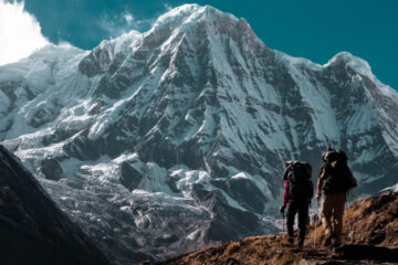
The Chandrashila summit is a vantage point that stands unparalleled among our treks. From the top of the summit, you see perhaps the greatest mountain views of our Indian Himalayas. It is like a grand feast — there is so much to take in that you cannot take all of it in. It is an experience many trekkers cannot forget.
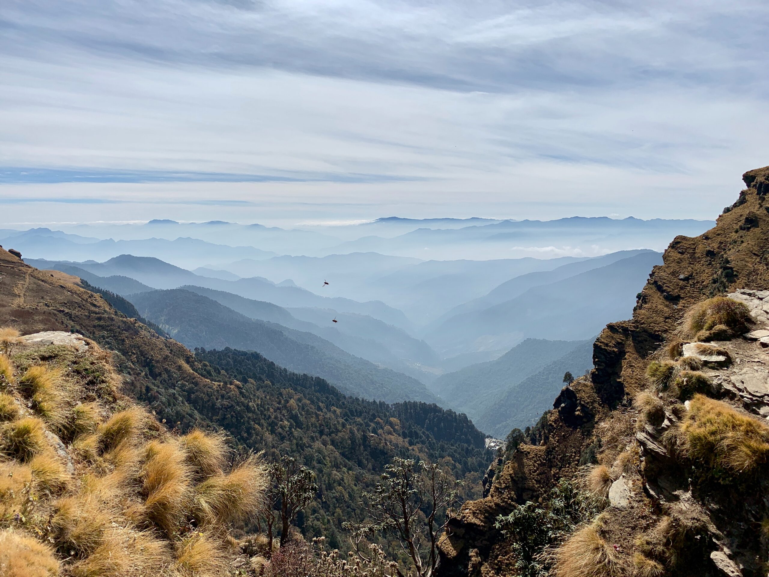
What do you see? From your left are the Gangotri range of peaks, Mt Thalaysagar, the Kedarnath and the Kedar dome. Mandani Parbat and Janhukut. The imposing Chaukhamba is right in front. Most of them are over 7,000 meters tall.
On your right are the Gauri Parbat, Hathi Parbat and Dunagiri. And then right ahead standing against the skyline in India’s tallest mountain, Mt Nanda Devi. Trekkers find it hard to believe that they are seeing Mt Nanda Devi.
If that’s not enough, to Mt Nanda Devi’s right, etched against the skyline are Mt Nanda Ghunti and Mt Trishul. Two of the most beautiful mountain summits in our country.
It is not just the grand views. In Spring, the trek in itself is special. The trail snaking through goes through the canopy of oak and rhododendron trees is almost dream-like. This trek is picture-perfect and you have one of the best rhodo forests which set the mountains ablaze with colours during March, April!
For us, just to catch the sight of Mt Chaukhamba from the shores of the Deoriatal is worth doing the entire trek. The Deoriatal lake glittering with green meadow around. But looming and towering over the lake is Mt Chaukhamba.
Besides Deoriatal, camping at the campsite of Baniya Kund is a delight. The dense forests leading to the campsite are something that we don’t get on other treks. And everything changes with the canopy of white everywhere.
Having said all that, the biggest thrill of the trek has to be the climb from Chopta to the Chandrashila summit. Climbing to the summit is an adventure that people do not forget in a lifetime. We have noticed trekkers breaking down in tears at the summit, such as the feeling of elation and a sense of accomplishment.
Deoriatal Chandrashila would be one of the better ones on our list for any beginners. Do not miss out on this opportunity.
Day 1- Drive from Rishikesh to Sari
Drive Distance: 190 km | Drive Duration: 7-8 hours | Pick up Time: 7.30 am | Location of a1 himalayas basecamp: sari
DAY 2 -Trek from Sari to Deoriatal
Trek Distance: 4.1 km | Trek Duration: 2.5 hours | Altitude Gain: 6,560 ft to 7810 ft
Day 3-Trek from Deoriatal to baniya kund via Rohini Bugyal
Trek Distance: 16 km | Trek Duration: 7-8 hours | Altitude Loss: 7810 ft to 7600 ft via 9,020 ft
If unable to do 16 km trek then can come back to Sari village by trek and drive to Baniyakund campsite, if a1himalayas vehicle is available then drive from Sari to Baniyakund is free and if not then trekkers will have to pay around Rs 1200.
Day 4-Trek from Baniya Kund to Chandrashila via Tungnath and back to baniya kund
Trek Distance: 9 km both side| Trek Duration: 7-8 hours | Altitude Gain: 8,520 ft to 12,083 ft via 11410 ft
Day 5- Drive from baniya kund to Rishikesh
Drive Distance: 210kms | Drive Duration: 7-8 hours
Day 1-Drive from Rishikesh to Sari
Sari, the base camp of the Deoriatal-Chandrashila trek, is an 8-hour drive from Rishikesh. The journey is picturesque, as you pass through Devaprayag, the confluence of rivers Alakananda and Bhagirathi to form the river Ganga. The entire journey traverses the mountainside, with the river flowing below you. A quick tip: Pick the window seat on the right to enjoy the views!
Sari is a small village with around 100 houses. If you reach Sari when the sun is still out, go down to the village and walk around. The paddy fields are so prettily laid out that they almost beckon to you. There is a small school amidst the fields. This school was built in 1947 and is the only school at Sari. The views around the village are gorgeous. This is also where you’ll get your first glimpse of the summit of Chandrashila!
You arrive at our a1himalayas Basecamp of Sari.
Day 2-Trek from Sari to Deoriata
Difficulty: Easy. The day starts from the village by climbing a few stairs, followed by a gradual climb on a well-defined rocky trail. A short walk on even terrain after an hour of climbing takes you to the campsite.
Note: Do not miss the sunset from Deoriatal. The alpen glow of Mt Chaukhamba and the reflections of it over the lake is a beautiful sight to behold.
Day 3- Trek from Deoriatal to baniya kund via Rohini Bugyal
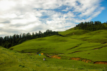
Today is the most scenic day of your trek and a treat for all nature lovers. Today’s trail is made spectacular with the Rhododendron covers that become denser and denser as you trek uphill. The Kedar dome and the Chaukhamba peaks also peek through the tree covers. You will spot two varieties of Rhododendrons here, red and pink and during the months of March and April, the trail is set ablaze in hues of crimson. The forest cover soon opens into a beautiful clearing, the Rohini Bugyal meadow which is lined with Rhododendrons on all sides.
The trek today is moderate starting with a gradual ascent followed by a slight descent, which eases to a gradual ascent until Rohini Bugyal. From Rohini Bugyal there’s a steep descent followed by a mix of ascents and descents to Baniyakund. As the Rhododendron cover clears up, you will get clear views of Chandrashila peak in the distance, and on your right below, you can see the Sari village once again.
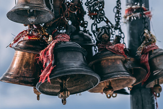
The trail passes through Kedarnath Sanctuary, so you may be able to spot some Himalayan Wildlife like red foxes and other small animal species and birds like Griffon Vultures, which are huge birds of prey as well as Verditer Flycatcher and Himalayan Woodpecker. Every now and then, you may also come across small shrines with prayer flags tied to them. These temples are built by the locals. Walk for 20 more minutes and you will reach a landmark temple, the Bagdwal temple and you will spot three paths branching out.
One route connects back to Sari village, another connects to Ukhimath and there’s a third descending path, which leads us to Rohini Bugyal. The Chandrashila and Kala Parvat become quite prominent from here. Walk for about 30 minutes and you will pass a small rivulet. This is your water source and you can fill your bottles here. Tread across a wooden bridge to cross the river and a small uphill climb will lead you to Rohini Bugyal.
As you climb uphill from Rohini Bugyal, the views get better and better and you will observe a series of shepherd huts lining the hills. During the summer months, the locals occupy these huts along with their livestock. The Rohini Bugyal meadows provide the perfect spot for cattle grazing. From here, crossing a few gradual ascents, you will reach Baniyakund. Further ahead, there is a motorable road that leads to Chopta, and from here take the trail on the right to reach the Baniyakund campsite, a clearing between the forests. You will stay overnight in Cottages/ Camp.
Day 4- Trek from Baniya Kund to Chandrashila via Tungnath and back to baniya kund
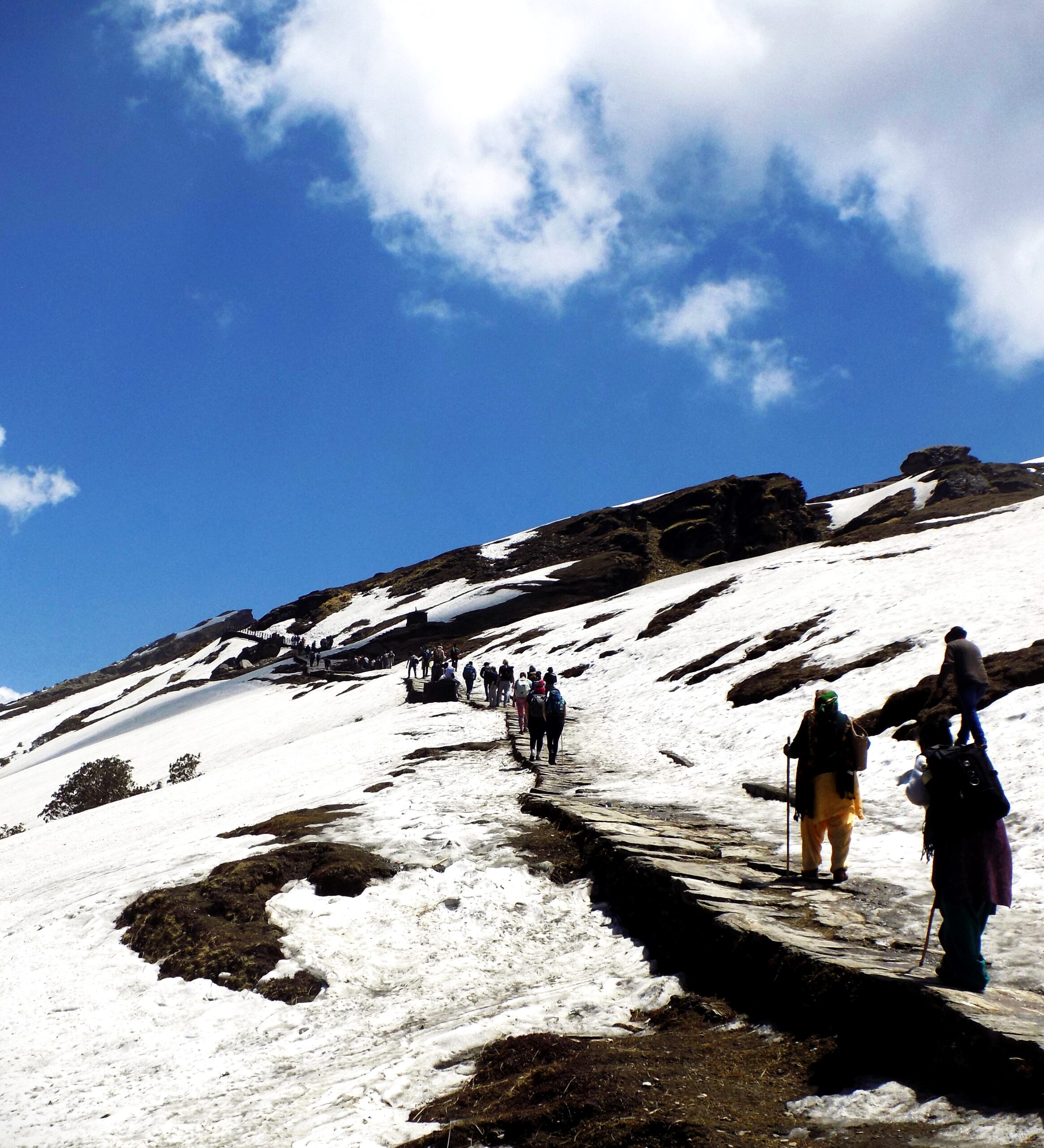
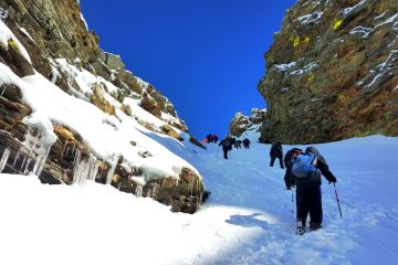
Today is the summit day and we will have an early start at the wee hours before sunrise so that we can catch the sunrise from Tungnath. The path from Chopta to Tungnath wades along a well-defined, concrete trail. The trek from Chopta to Tungnath is about 3 km and the trail entwines along meadows and forests before making way to the Tungnath temple and 1.5 km from Tungnath lies Chandrashila summit. The trail remains buried deep in snow during the winters adding to the challenge of the climb to Chandrashila from Tungnath, which is already quite steep.
The trail from Chopta to Tungnath is well-defined which makes it quite accessible but at the same time, it is a little steep with numerous scissor bends. As you make your way to the second last scissor bend, you can see the Tungnath temple on the right and the Chandrashila summit. The views start getting increasingly better from here and Tungnath Temple is just half a kilometer away. On the left is a view overlooking a valley of Birch trees, which is again a prime spot to sight bird species like Monal and Griffon Vultures.
Soon you will reach the Tungnath temple, which remains closed in winter and you will find snow until April here. The Tungnath Temple is one of the Panch Kedars and is steeped in mythology and folklore. The legend according to Mahabharata goes that the Panch Kedars was built by the Pandavas, asking for Lord Shiva’s forgiveness and atonement of their sins incurred by killing their kins in the battle of Kurukshetra. Lord Shiva appeared in a bull form and parts of the bull appeared in these five locations, where the shrines were built. Tungnath is where the limbs and chest of the bull appeared.
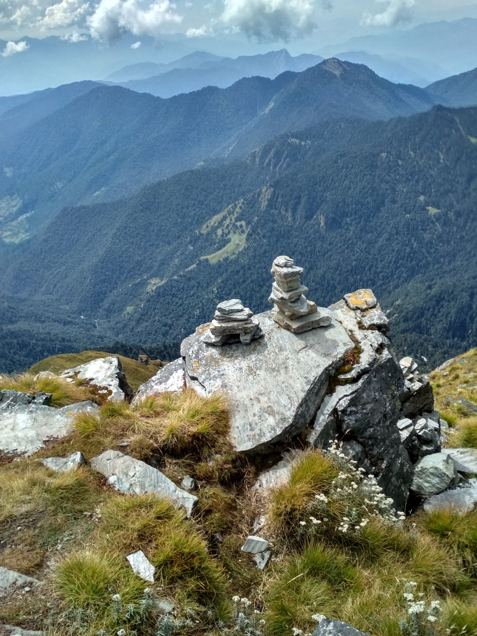
From Tungnath temple, the trek to the Chandrashila summit is a short but challenging one as it is pretty steep. Crampons and gaiters are a must if you are attempting this trek in the winter. Follow your trek leaders instructions to safely make it to the summit. The trail to Chandrashila starts just behind the temple complex. You ascend 600 ft from Tungnath conquering a very steep climb. Once you reach the Chandrashila Base, the Chandrashila peak becomes visible and another 30 to 45 minutes climb takes you to the summit, where you will get some epic mountain views including Mt. Trishul, Nanda Ghunti, Nanda Devi, Thalaysagar, Gangotri Ranges, Kamet, Chaukhamba, Kedar Dome, Dunagiri, Jahanukut and more.
The sunrise view from the Chandrashila summit is unlike any you will ever see and this is one of the best photo points in the Himalayas. At Chandrashila summit there is another temple dedicated to Lord Shiva, which is believed to have been built by Lord Rama for the atonement of the sin of killing Ravana. The trek back to Chopta follows the same path. Retrace your steps back to Chopta and from there you will drive back to the Baniyakund Cottages/ Camp.
Day 5- Drive from baniya kund to Rishikesh
Drive 210 km (7 hrs drive)
Reach Rishikesh by 5:00 pm
After morning tea move to Rishikesh (breakfast and lunch on the way, exclusive of charges)
This is the last day of your journey, where we will drop you off at Rishikesh. Board your vehicles at Baniyakund and its a 7-hour drive to Rishikesh, along the same mountain roads you came in, taking back with you warm memories of the mountains. We will drop you off at Rishikesh by 6:30 PM and you can book your further journey onwards.
By Air :-
Jolly Grant Airport is the airport serving Dehradun, located about 25 km from the city. There is a daily flight from Delhi to Dehradun. Come one day early if planning to come by flight.
By Train :-
Take the overnight train to Dehradun/Haridwar from Delhi
- Nandadevi Express – Train no: 12205 (Departure 11:50pm; Arrival – 5:40am)
- Dehradun Express – Train no: 12687 (Departure – 9:10pm; Arrival – 5:00am)
By Bus:-
There is regular bus service from Delhi to Rishikesh / Haridwar, from Delhi to ISBT Kashmere Gate. We would suggest you to take only government buses from ISBT Kashmere Gate. Private buses ply from outside ISBT and they are not trust worthiness. Usually buses drop you at Haridwar bus stop and Rishikesh.
Includes
- Meals during the trek
- Transportation from Rishikesh to back to Rishikesh
- Dinner on arrival day in Sari
- Forest Permits/Camping Charges (only if availing transportation through A1 Himalayas). Included only up to amount charged for Indian Nationals
- Safety Equipment includes static rescue rope, seat harness, carabiners, pulleys
- Trek guide, cook, helpers, porters & mules for carrying common luggage
- Services of a Certified Trek Leader
Excludes
- Meals during road journeys
- Carriage of Personal Bags during the trek
- Any kind of Insurance
- Any expense of personal nature
- Any expense not specified in the inclusion list.
1) Trekking Shoe/Snow Shoe
2) Rucksack/Back Pack
3) Rucksack cover (Waterproof)
4) Daypack/Knapsack
5) Undergarments/Innerwear
6)Woolen socks
7) Woolen gloves
8) Waterproof gloves
9) T-shirt
10) Trek pants
11) Camp sandal
12) Balaclava/Woolen skull
cap/Monkey Cap
13) Sun cap/Wide-brimmed
Hat/Bandana
14) Walking Sticks/Trekking
Poles/Ski Poles
15) Heavy Jacket
16) Windproof Jacket/Wind
Cheater
17)Raingear/Poncho/Waterproof clothing
18) Water bottle/Hydration pack
19) Sunscreen lotion
20) Sunglasses
21) ChapStick/Cold &
Moisturizing cream
22) Toothbrush and toothpaste
23) Towel
24) Hand sanitizer
25) Tissue roll ( Toilet)
26) Anti Fungal Powder
27) Torch/Head Lamp with extra batteries
28) Knee cap
29) Camera with extra cells
30) Dry food items
31) Personal first-aid kit
32) Medicines (This is a simple
guide line and a doctor’s
consultation is recommended.)
Altitude is a risk. Before you begin the trek, you should be aware of the effects of high altitude on your body. Acute Mountain Sickness (AMS) symptoms include a moderate headache, nausea, and overall discomfort.
Reponse: If you have any of these symptoms, notify the trek leader immediately and follow his advice. To deal with the scenario, each campsite contains a stretcher, a fully prepared first aid kit, and oxygen cylinders.
Weather Risk : No one can guarantee snow, rain, or sunlight, even if we keep a constant eye on the weather. Please keep in mind that your safety is our primary priority, and if the weather isn’t cooperating, we won’t leave the campsite.
Response: The choice to go or wait for better weather will be made solely by the Trek Leaders and Guides.
Risk: Injury is a possibility. While trekking across difficult terrains, minor injuries such as calf sprains, bruising, and other minor ailments are prevalent. Serious injuries, such as fractures or significant cuts, are quite uncommon.
Response: All of our Trek Leaders are trained in wilderness first aid. They’ve been taught to deal with emergencies and have a well-stocked first-aid equipment to deal with minor injuries. In the event of major injuries, the patient is carried to the nearest road-head on a stretcher and taken to the nearest medical facility.
DO’S AND DON’TS ON A TREK
1. Alcohols or any other intoxicating products ‘’STRICTLY PROHIBHITED’’
during the trek.
2. Always pay heed to the trek guides or instructors.
3. Try not to leave the group under any circumstances.
4. Avoid trekking during the nights as it is extremely dangerous.
5. Avoid using earphones as that might hinder your hearing.
6. Do not participate or encourage littering of the places in any form.
7. While visiting the local villages and tourist sites, obey the local guidelines
and instructions.
8. Do not harm or interrupt the local sentiments of the places.
IMPORTANT:
Your safety is of paramount concern while traveling with A1 Himalayas.
Please note that your leader has the authority to amend or cancel any part of
the itinerary if it is deemed necessary due to safety concerns. Since adventure
entails traveling in remote mountainous regions, we cannot guarantee that we
will not deviate from it. Weather conditions, health condition of a group
member, unexpected natural disasters, etc., can all contribute to changes in
the itinerary. The leader will try to ensure that the trip runs according to plan,
but please be prepared to be flexible if required.